
1. Introduction
This instruction manual provides essential information for the safe and efficient operation of your PREXISO MT-105 Non-Prism Total Station. Please read this manual thoroughly before using the device to ensure proper handling, setup, measurement procedures, and maintenance. Keep this manual in a safe place for future reference.
The PREXISO MT-105 is a high-performance total station designed for precise surveying and measurement tasks. It features a non-prism measurement capability, 2-axis compensation, a laser plummet with shifting function, and a user-friendly Japanese LCD display.
2. Safety Information
Always observe the following safety precautions to prevent injury and damage to the instrument:
- Do not look directly into the laser beam. Laser radiation can cause eye damage.
- Ensure the instrument is securely mounted on a stable tripod to prevent tipping.
- Operate the device within the specified temperature range (-20°C to +50°C).
- Protect the instrument from severe impacts and vibrations.
- Use only approved batteries and chargers.
- Keep the instrument dry. Although it has IP66 dust and water protection, avoid submerging it.
3. Product Overview and Components
The PREXISO MT-105 Total Station is designed for robust field use. Key components include the main unit, display, keypad, and various optical and electronic parts.
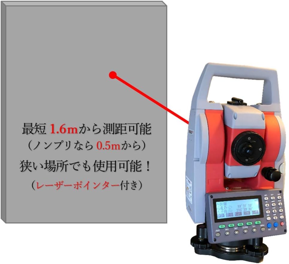
Figure 3.1: Main unit of the PREXISO MT-105 Total Station. This image shows the overall design of the total station, highlighting its compact and durable construction.

Figure 3.2: PREXISO MT-105 Total Station. This image displays the total station with the PREXISO brand logo, emphasizing its professional appearance and certification by the Geospatial Information Authority of Japan.
3.1 Key Features
- Non-Prism Measurement: Capable of measuring distances from 0.5m (non-prism) to 5000m (with 1 prism).
- 2-Axis Compensation: Automatically corrects for tilt in both horizontal and vertical axes, ensuring accurate angle measurements.
- Laser Plummet with Shifting Function: Facilitates easy and precise centering over a survey point.
- Japanese LCD Display: Clear, backlit, double-sided display for easy readability in various conditions.
- Data Storage: Internal memory for 50,000 points and support for USB memory for convenient data transfer.
- IP66 Protection: Dust-tight and protected against powerful water jets.

Figure 3.3: Diverse Functions. This image illustrates various features of the MT-105, including laser plummet, 2-axis compensation, non-prism measurement, laser pointer, shifting, IP66 rating, USB slot, data management (TSLink), and a multi-functional case.
4. Setup
4.1 Unpacking and Inspection
Carefully unpack the total station and all accessories. Verify that all items listed in the packing list are present and undamaged. Report any discrepancies or damage to your supplier immediately.

Figure 4.1: Robust Storage Case. The durable storage case protects the total station and can also accommodate mini prisms and pin poles.
4.2 Battery Installation and Charging
The MT-105 uses rechargeable Ni-MH batteries. Ensure batteries are fully charged before use. Insert the charged battery into the battery compartment as shown in the diagram (refer to product diagram for battery compartment location). A full charge provides approximately 10 hours of continuous operation.
4.3 Mounting the Instrument
Mount the total station securely onto a stable tripod. Ensure the tripod legs are spread wide and firmly planted on the ground. Use the central screw to attach the instrument to the tripod head.
4.4 Leveling and Centering
Accurate leveling and centering are crucial for precise measurements.
- Rough Leveling: Adjust the tripod legs to bring the circular bubble into the center.
- Fine Leveling: Use the leveling screws on the tribrach to center the plate bubble.
- Centering with Laser Plummet: Activate the laser plummet. Adjust the tribrach's shifting mechanism to align the laser dot precisely over the survey point. The shifting function allows for easy adjustment without disturbing the leveling.

Figure 4.2: Laser Plummet and Shifting Function. This image demonstrates how the laser plummet and shifting mechanism simplify centering the instrument over a point.
4.5 2-Axis Compensation
The MT-105 features a 2-axis compensation system that automatically detects and corrects for any tilt of the vertical axis in both front-back and left-right directions, ensuring highly accurate angle measurements.

Figure 4.3: 2-Axis Compensation Function. This diagram illustrates how the 2-axis compensation detects and corrects for tilt, ensuring precise angle measurements.
5. Operating Instructions
5.1 Power On/Off and Display
Press the power button to turn on the instrument. The Japanese LCD display will illuminate. The display is double-sided and backlit for clear visibility. To power off, press and hold the power button.

Figure 5.1: LCD Display Program Menu. The display shows various program options such as Resection, Offset Measurement, Traverse Measurement, REM Measurement, and Area Measurement.
5.2 Basic Measurement Modes
The MT-105 offers various measurement modes accessible via the keypad and display menu.
- Angle Measurement: Set the horizontal angle to zero or a known value. Rotate the instrument to measure horizontal and vertical angles. Angle accuracy is 5 arc seconds, with display options of 1", 5", or 10".
- Distance Measurement (EDM):
- Non-Prism Mode: For measuring distances to surfaces without a prism. Minimum measurable distance is 0.5m. Range up to 800m.
- Prism Mode: For measuring distances to a prism. Range up to 5000m with a single prism.
Distance accuracy is ±(2+2ppm×D)mm (maximum). The shortest focus distance is 1.6m.

Figure 5.2: Non-Prism Measurement. The MT-105 can measure distances from a minimum of 1.6m (0.5m in non-prism mode), making it suitable for narrow spaces. It includes a laser pointer for targeting.
5.3 Advanced Measurement Functions
The MT-105 supports various advanced surveying programs:
- Resection: Determine the instrument's position by measuring known points.
- Offset Measurement: Measure points that cannot be directly observed.
- Traverse Measurement: Establish control points by measuring angles and distances.
- REM Measurement: Remote Elevation Measurement.
- Area Measurement: Calculate the area of a polygon defined by measured points.
- Stakeout: Layout points from design data.

Figure 5.3: Coordinate Measurement. Diagram illustrating the principle of coordinate measurement.

Figure 5.4: Resection. Diagram illustrating the resection method for determining instrument position.

Figure 5.5: Traverse Measurement. Diagram illustrating the process of traverse measurement.

Figure 5.6: Stakeout. Diagram illustrating the stakeout procedure.
5.4 Data Management
The MT-105 allows for efficient data storage and transfer.
- Internal Memory: Stores up to 50,000 points.
- USB Memory: Connect a commercial USB memory stick to the USB port for easy data backup and transfer to a computer.
- RS232C Cable: Use the RS232C interface for direct data communication with a computer.

Figure 5.7: USB Memory Port. The USB port allows for convenient data management and transfer using commercially available USB memory sticks.
6. Maintenance
6.1 Cleaning
- Gently wipe optical parts (lens, display) with a soft, lint-free cloth. Do not use abrasive cleaners.
- Clean the instrument body with a damp cloth. Avoid using strong solvents.
6.2 Storage
When not in use, store the total station in its original carrying case in a dry, temperature-controlled environment. Remove batteries if storing for extended periods.
6.3 Calibration
Regular calibration by authorized service personnel is recommended to maintain measurement accuracy. Refer to the specifications for recommended calibration intervals.
7. Troubleshooting
This section provides solutions to common issues you might encounter. For problems not listed here, please contact customer support.
| Problem | Possible Cause | Solution |
|---|---|---|
| Instrument does not power on. | Low or uncharged battery. | Charge the battery or replace with a charged one. |
| Inaccurate measurements. | Instrument not level or compensated. | Re-level the instrument and ensure 2-axis compensation is active. |
| Laser plummet not visible. | Bright ambient light or dirty lens. | Use in shaded areas or clean the laser plummet lens. |
| Data transfer issues. | Incorrect cable connection or USB memory format. | Check connections, ensure USB memory is properly formatted (e.g., FAT32). |
8. Specifications
The following table details the technical specifications of the PREXISO MT-105 Total Station.

Figure 8.1: PREXISO MT-105 Detailed Specifications. This image provides a comprehensive table of technical specifications for the total station.
| Category | Item | Specification |
|---|---|---|
| Telescope | Effective Aperture | 45 mm |
| Magnification | 26x | |
| Image | Erect | |
| Field of View | 1° 30' | |
| Resolving Power | 3.5" | |
| Shortest Focus Distance | 1.6 m | |
| Angle Measurement | Reading Method | Absolute Encoder |
| Accuracy | 5" | |
| Minimum Display | 1" / 5" / 10" (selectable) | |
| Tilt Angle Correction Range | ±3' | |
| Tilt Correction Mode | 2-axis / 1-axis / Off (selectable) | |
| Distance Measurement (EDM) | Method | Phase difference method |
| Light Source | Red laser diode: Wavelength 685nm | |
| Laser Class | Class 3R | |
| Accuracy (Prism) | ±(2+2ppm×D) mm | |
| Accuracy (Non-Prism 4m+) | ±(2+2ppm×D) mm | |
| Accuracy (Non-Prism) | ±(5+2ppm×D) mm | |
| Measurement Range (1 Prism) | 1.6 m - 5000 m | |
| Measurement Range (Non-Prism) | 0.5 m - 800 m | |
| Measurement Time (Fine) | Approx. 1.8 sec (initial 2.5 sec) | |
| Measurement Time (Tracking) | Approx. 0.4 sec (initial 1.5 sec) | |
| Laser Plummet | Light Source | Red laser diode: Wavelength 635nm |
| Laser Class | Class 2 | |
| Accuracy | ±2mm / 1.5m | |
| Spot Diameter | φ2mm / 1.5m | |
| Bubble Level | Circular Bubble | 8' / 2mm |
| Plate Bubble | 30" / 2mm | |
| Display Unit | Display | Japanese LCD (double-sided, backlit) |
| Data Recording | Max Recordable Points | 50,000 points |
| Interface | RS232C cable & USB memory | |
| Power Supply | Battery | Rechargeable Ni-MH battery |
| Continuous Operating Time | 10 hours | |
| Voltage | DC 7.2V | |
| Operating Temperature Range | -20°C to +50°C | |
| General | Dimensions (D×W×H) | 190(D)×210(W)×350(H) mm |
| Weight | 5.7 kg |
Note: Specifications are subject to change without notice.

Figure 8.2: Geospatial Information Authority of Japan Certification. The PREXISO MT-105 is certified as a Class 2A Total Station by the Geospatial Information Authority of Japan (Registration No. 521, registered March 31, 2021).
9. Warranty and Support
9.1 Warranty Information
Your PREXISO MT-105 Total Station comes with a standard manufacturer's warranty. Please refer to the warranty card included with your product for specific terms and conditions, including warranty period and coverage details. Keep your purchase receipt as proof of purchase.
9.2 Customer Support
For technical assistance, troubleshooting, or service requests, please contact your local PREXISO dealer or authorized service center. You can also visit the official PREXISO website for support resources and contact information.