
Garmin 010-02092-00
Contents
Garmin GPSMAP 8412 MFD User Manual
Model: 010-02092-00
Product Overview
The Garmin GPSMAP 8412 Multi-Function Display (MFD) is a 12-inch full HD multi-touch LCD unit designed for marine navigation. It comes with a worldwide basemap and incorporates advanced sailing features. This device supports integration with various optional marine systems such as radar, satellite weather, Automatic Identification System (AIS), cameras, and other instrumentation. It is also compatible with FUSION-Link™ radios, Garmin Helm, Garmin SmartMode, and ActiveCaptain for enhanced connectivity and control.
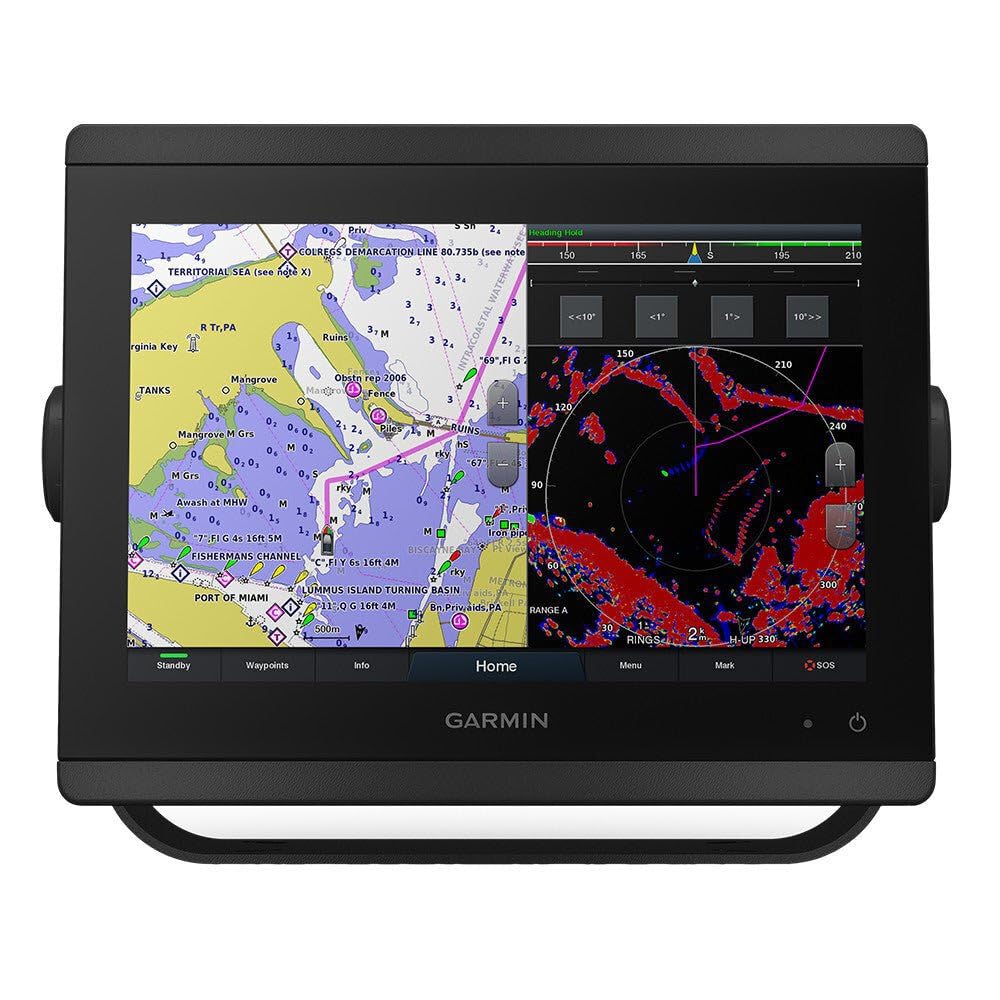
This image displays the Garmin GPSMAP 8412 Multi-Function Display. The left side of the screen shows a detailed marine chart with navigational aids, depth contours, and land features, including 'PORT OF MIAMI' and 'FISHERMANS CHANNEL'. The right side of the screen shows a radar display with various targets and range rings. The bottom of the screen features touch buttons for 'Standby', 'Waypoints', 'Info', 'Home', 'Menu', 'Mark', and 'SOS'. The Garmin logo is visible below the screen.
Setup and Installation
What's in the Box
- GPSMAP 8412 MFD unit
- Worldwide basemap pre-loaded
- Power/data cable
- NMEA 2000 drop cable
- NMEA 2000 T-connector
- Bail mount with knobs
- Flush mount hardware
- Protective cover
- Documentation
Mounting the Device
The GPSMAP 8412 MFD can be installed using either a bail mount or a flush mount. The bail mount allows for adjustable viewing angles and is suitable for surface installation. For a more integrated look, the device can be flush-mounted into a panel. Ensure the mounting location provides adequate ventilation and is protected from excessive heat and direct sunlight. The device is designed for marine environments, but proper installation is crucial for longevity.
Power and Network Connections
Connect the power/data cable to a 10-32 Vdc power source. Ensure proper polarity. The device supports NMEA 2000 networking for integration with other marine electronics, allowing for data sharing such as GPS, sonar, radar, and engine information. Connect the NMEA 2000 drop cable to the device and the T-connector to your NMEA 2000 backbone. The unit also features Wi-Fi connectivity for wireless updates and integration with mobile devices via the ActiveCaptain app.
Operating Instructions
Basic Navigation and Touchscreen Use
The GPSMAP 8412 features a multi-touch capacitive touchscreen for intuitive operation. Use pinch-to-zoom gestures on charts, swipe to navigate menus, and tap to select options. The home screen provides quick access to frequently used functions like chartplotter, radar, and sonar. Customizable profiles allow users to tailor the display to their specific needs.
Chartplotter Functions
The pre-loaded worldwide basemap provides fundamental navigational data. For enhanced detail, optional Garmin BlueChart g3 or LakeVü g3 charts can be installed. Create and manage waypoints, routes, and tracks directly on the screen. Utilize features such as auto guidance, depth shading, and fishing charts for optimized navigation and fishing experiences.
Advanced Sailing Features
The device includes specialized sailing features to assist mariners. These include laylines, enhanced wind rose, heading and course-over-ground lines, true wind data fields, and tide/current information. Integration with compatible wind sensors provides real-time apparent and true wind angle/speed data.
Connectivity and Integration
The GPSMAP 8412 supports a wide range of connectivity options:
- Wi-Fi: Connect to the ActiveCaptain app on your mobile device for smart notifications, software updates, chart purchasing, and community features.
- NMEA 2000: Integrate with compatible sensors, engines, autopilots, and other displays.
- Garmin Marine Network: Share maps, user data, radar, and IP camera video across multiple compatible Garmin devices on your vessel.
- FUSION-Link™: Control compatible FUSION-Link audio systems directly from the MFD.
- Garmin Helm: View and control your MFD from a compatible smartphone or tablet.
- Garmin SmartMode: Allows for quick and easy access to pre-set layouts for different activities like docking, cruising, fishing, and anchoring.
Maintenance
Cleaning the Device
To clean the screen and casing, use a soft, clean, lint-free cloth. For stubborn dirt or smudges, dampen the cloth with a mild glass cleaner or fresh water. Avoid using abrasive cleaners, solvents, or ammonia-based products, as these can damage the screen coating and plastic components. Ensure the device is powered off before cleaning.
Software Updates
Garmin regularly releases software updates to improve performance, add new features, and address issues. It is recommended to keep your device's software up to date. Updates can typically be performed via the ActiveCaptain app using Wi-Fi, or by downloading the update file to an SD card from the Garmin website and inserting it into the device.
Storage
When storing the device for extended periods, especially in cold temperatures, remove it from the vessel if possible and store it in a dry, temperature-controlled environment. Use the protective cover to prevent scratches and dust accumulation on the screen.
Troubleshooting
Device Does Not Power On
- Check the power cable connection to the device and the power source.
- Verify the power source (battery or breaker) is supplying adequate voltage (10-32 Vdc).
- Inspect the fuse in the power cable for continuity and replace if blown.
- Ensure the power button is pressed firmly and held for a few seconds.
No GPS Signal
- Ensure the device has a clear view of the sky. Obstructions can block satellite signals.
- Verify that the internal GPS antenna is enabled in the system settings, or that an external GPS antenna is properly connected and powered.
- Move the device away from other electronic equipment that may cause interference.
Touchscreen Unresponsive
- Clean the screen to remove any dirt, salt, or water that might interfere with touch input.
- Perform a soft reset by powering the device off and on again.
- If the issue persists, check for available software updates.
Specifications
| Feature | Detail |
|---|---|
| Brand | Garmin |
| Model Number | 010-02092-00 |
| Screen Size | 12 Inches |
| Display Type | Full HD Multi-touch LCD |
| Connectivity Technology | Wi-Fi, NMEA 2000, Garmin Marine Network |
| Map Type | Worldwide Basemap (pre-loaded) |
| Item Weight | 13.15 Pounds |
| Package Dimensions | 11.93 x 8.5 x 2.99 inches |
| Vehicle Service Type | Boat |
| Mounting Type | Bail Mount, Flush Mount |
| Included Components | MFD unit, basemap, WiFi, sailing features, optional radar/sat WX/AIS/cameras/instrumentation support, FUSION-Link™ compatible radios, Garmin Helm, Garmin SmartMode, ActiveCaptain support |
Warranty and Support
Garmin products are designed for reliability and performance. For specific warranty details, please refer to the warranty information included with your product packaging or visit the official Garmin website. Garmin offers technical support and customer service to assist with any questions or issues you may encounter with your GPSMAP 8412 MFD.
For further assistance, please contact Garmin Customer Support or visit their online support center for FAQs, manuals, and software downloads.
Documents and downloads
Ask a question about this manual
Ask about setup, troubleshooting, compatibility, parts, safety, or missing instructions. Manuals+ will review the question and use this page’s manual context to help answer it.