1. Introduction
The Quectel LC29H LC29HBA module is a high-precision GNSS (Global Navigation Satellite System) module designed for advanced positioning applications. It supports ADR (Advanced Dead Reckoning) and dual-frequency L1+L5 reception, enabling centimeter-level RTK (Real-Time Kinematic) differential GPS and Beidou positioning. This manual provides essential information for setting up, operating, and maintaining your LC29H module.

2. Setup Guide
This section outlines the steps to properly set up your LC29H module for operation.
2.1 What's in the Box
- Quectel LC29HBA GNSS Module
- L1+L5 GNSS Antenna (depending on package)
- USB Type-C Cable (depending on package)

2.2 Hardware Connections
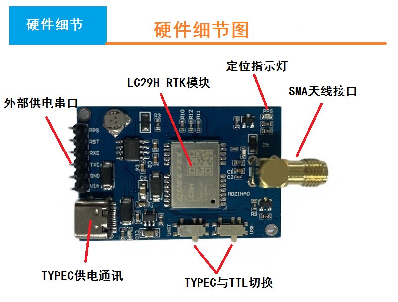
Refer to the diagram below for connecting the module components:
- SMA Antenna Interface: Connect the L1+L5 GNSS antenna to the SMA connector on the module. Ensure a secure connection.
- TYPEC Power Supply & Communication: Use the USB Type-C port for both power supply and data communication with a host device (e.g., computer, development board).
- External Power Supply Serial Port: An external power supply can be connected via dedicated pins, supporting 5V input.
- TYPEC and TTL Switching: The module supports switching between TYPEC and TTL for serial communication. Configure as needed for your application.
- Positioning Indicator Light: This LED indicates the status of the GNSS positioning.
3. Operating Instructions
The LC29H module offers high-precision positioning through its multi-constellation and RTK capabilities.
3.1 RTK Fixed Positioning
The LC29H can receive signals from multiple satellite constellations including Beidou, GPS, GLONASS, and QZSS with high sensitivity. By integrating with a differential server, it can quickly achieve RTK fixed-point positioning.
3.2 RTK Service Configuration
To utilize RTK services, you need to access a mobile service or a CORS (Continuously Operating Reference Station) account. This involves uploading GGA data to a server and receiving RTCM (Radio Technical Commission for Maritime Services) base station data from the server.
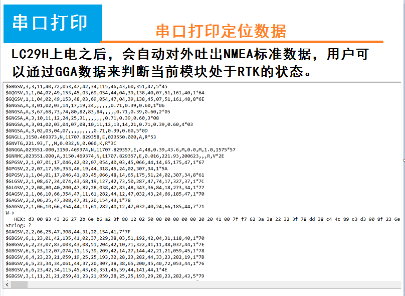
3.3 Data Output and Monitoring
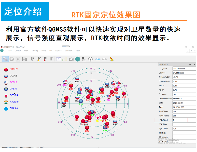
Upon power-on, the LC29H module automatically outputs standard NMEA (National Marine Electronics Association) data via its serial port. Users can analyze the GGA (Global Positioning System Fix Data) sentences within this data to determine the current RTK status of the module.
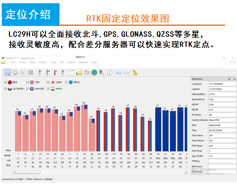
For visual monitoring and analysis of satellite data, signal strength, and RTK convergence time, the official QGNSS software can be used.
4. Maintenance
The Quectel LC29H module is designed for robust performance with minimal maintenance. To ensure longevity and optimal operation:
- Keep the module clean and free from dust and moisture.
- Avoid exposing the module to extreme temperatures or direct sunlight for prolonged periods.
- Ensure all connections are secure and free from corrosion.
- Handle the module with care to prevent physical damage.
5. Troubleshooting
If you encounter issues with your LC29H module, consider the following:
- No Power/No Indicator Light: Check the power supply connection and ensure it provides the correct voltage (5V). Verify the USB cable is properly connected.
- No Satellite Fix: Ensure the GNSS antenna is correctly connected and has a clear view of the sky. Obstructions can block satellite signals.
- RTK Not Achieving Fixed Status: Verify your RTK service configuration (CORS account, GGA data upload, RTCM data reception). Ensure the differential correction data is being received correctly.
- Communication Issues: Check the USB or serial TTL connections. Ensure the correct drivers are installed on your host device and the baud rate settings match the module's configuration.
- Inaccurate Positioning: Confirm the antenna is placed in an optimal location. Environmental factors like multi-pathing (signals reflecting off surfaces) can affect accuracy.
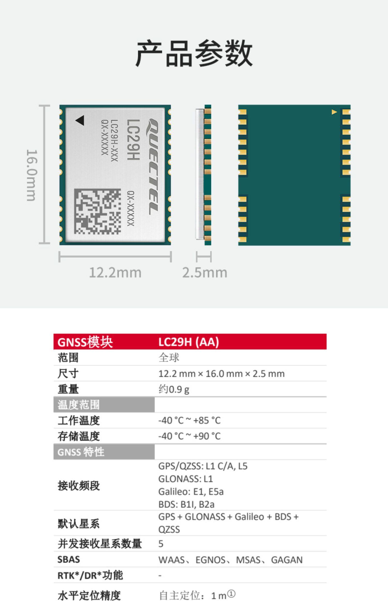
6. Specifications
Detailed technical specifications for the Quectel LC29H GNSS module and its development board:
| Feature | Specification |
|---|---|
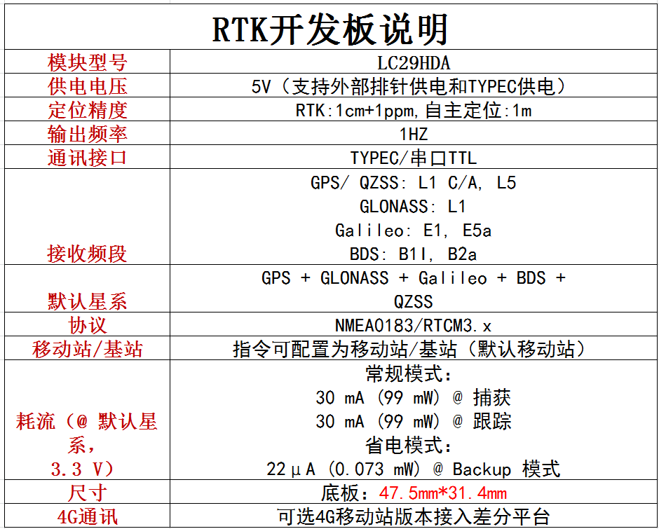
| Model Number | Quectel LC29H(BA) / LC29HDA |
| Range | Global |
| Module Dimensions | 12.2mm x 16.0mm x 2.5mm |
| Weight | Approx. 0.9g |
| Operating Temperature | -40°C to +85°C |
| Storage Temperature | -40°C to +90°C |
| Power Supply Voltage | 5V (External pin or TYPEC) |
| Positioning Accuracy (RTK) | 1cm + 1ppm |
| Positioning Accuracy (Autonomous) | 1m |
| Output Frequency | 1 Hz |
| Communication Interface | TYPEC / Serial TTL |
| Receiving Frequency Bands | GPS/QZSS: L1 C/A, L5 GLONASS: L1 Galileo: E1, E5a BDS: B1I, B2a |
| Default Constellation | GPS + GLONASS + Galileo + BDS + QZSS |
| Concurrent Reception Satellites | 5 |
| SBAS Support | WAAS, EGNOS, MSAS, GAGAN |
| Protocols | NMEA0183 / RTCM3.x |
| Mobile/Base Station Mode | Configurable (default mobile station) |
| Current Consumption (3.3V) | Normal Mode: 30 mA (99 mW) @ Capture / Tracking Power Saving Mode: 22 µA (0.073 mW) @ Backup |
| Baseboard Dimensions | 47.5mm x 31.4mm |
| 4G Communication | Optional 4G mobile station version for differential platform |
7. User Tips
- For best RTK performance, ensure your base station setup is stable and provides reliable differential corrections.
- Always use a high-quality L1+L5 antenna for optimal signal reception and accuracy.
- When troubleshooting, start by checking power and basic connections before delving into software configurations.
- Keep the module's firmware updated to benefit from performance improvements and new features.
8. Warranty and Support
8.1 Warranty Information
This product is covered by a standard manufacturer's warranty. Please refer to your purchase documentation for specific warranty terms and duration. Defective products may be eligible for exchange within 30 days of the order date. Processing returns may take up to 7 business days after receipt of the product.
8.2 Technical Support
For technical assistance, documentation, or further inquiries, please contact your vendor or the official Quectel support channels. Ensure you have your product model and any relevant error messages ready when seeking support.


