1. Introduzione
This manual provides detailed instructions for the setup, operation, and maintenance of your Bushnell Onix 200 Portable GPS Navigator. The Onix 200 is designed for outdoor use, offering navigation capabilities with satellite and aerial photos on a 2.7-inch sunlight-readable LCD screen. It features a rugged, waterproof design (IPX7) and 32 MB of internal memory for storing navigational data.
2. Prodotto finitoview
2.1 Caratteristiche principali
- Navigation with satellite and aerial photos.
- Rugged rubber armor and IPX7 waterproof rating.
- Sunlight-readable 2.7-inch LCD screen.
- Utente Profiles for customized activity settings.
- Night-mode screen viewopzione di ing.
- 32 MB internal memory.
- Connettività USB.
2.2 Componenti
The Bushnell Onix 200 package typically includes:
- Bushnell Onix 200 GPS Unit
- Supporto da polso
- Cavo USB (per trasferimento dati e ricarica)
- Manuale dell'utente (questo documento)
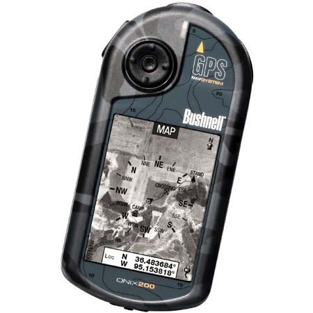
Figure 1: Bushnell Onix 200 handheld GPS unit, showing its rugged design and screen.
3. Impostazione
3.1 Installazione della batteria
The Bushnell Onix 200 does not include batteries. It requires standard AA batteries (not included). To install:
- Individuare il coperchio del vano batterie sul retro dell'unità.
- Aprire il coperchio facendolo scorrere o sbloccandolo secondo le indicazioni.
- Insert the required number of AA batteries, ensuring correct polarity (+/-).
- Chiudere bene il coperchio del vano batteria per mantenere la tenuta stagna.
3.2 Accensione iniziale e impostazioni di base
- Tenere premuto il pulsante di accensione finché lo schermo non si illumina.
- Upon first use, the device may prompt you to set basic preferences such as language, time zone, and measurement units. Follow the on-screen instructions.
- Allow the device to acquire a GPS signal. This may take several minutes, especially during the first use or after a long period of inactivity. Ensure you are in an open area with a clear view del cielo.
3.3 Collegamento a un computer
Use the provided USB cable to connect the Onix 200 to your computer for data transfer, map updates, or firmware updates. The device is compatible with Windows operating systems.
4. Istruzioni per l'uso
4.1 Navigation with Satellite/Aerial Photos
The Onix 200 allows you to overlay navigation information directly onto satellite or aerial photographs. This feature provides enhanced situational awareness, especially in unfamiliar terrain.
- Access the map view dal menu principale.
- Select the desired map type (e.g., satellite, aerial, USGS map) from the display options.
- Use the touch screen or voice controls to pan, zoom, and interact with the map.
- Your current position will be indicated on the map, along with any loaded waypoints or routes.
4.2 Utente Profiles
The "User Profiles" feature allows you to customize the device's settings and menu options based on your activity (e.g., hiking, fishing, hunting). This streamlines access to relevant functions.
- Vai alla sezione "Pro"files" section in the main menu.
- Seleziona un professionista esistentefile oppure crearne uno nuovo.
- Customize settings such as display preferences, data fields, and shortcut menus for that specific activity.
- Activate the desired profile before starting your activity.
4.3 Modalità notturna
For low-light conditions, activate the night-mode screen viewing option. This adjusts the display's backlight and color scheme to reduce eye strain and improve visibility in the dark.
- Accedi alle impostazioni di visualizzazione dal menu principale.
- Toggle the "Night Mode" option to ON.
Metodi di controllo 4.4
The Onix 200 supports both touch screen and voice control for interacting with the device. Refer to the on-screen prompts and the device's internal help system for specific voice commands.
5. Manutenzione
5.1 Pulizia del dispositivo
- Pulisci lo schermo e l'esterno con un panno morbido, damp, panno privo di pelucchi.
- Do not use abrasive cleaners, solvents, or aerosol sprays, as these can damage the device's finish and screen.
- Prima di collegare i cavi, assicurarsi che tutte le porte siano asciutte.
5.2 Waterproofing Care (IPX7)
The Onix 200 is waterproof to IPX7 standards, meaning it can withstand immersion in water up to 1 meter for 30 minutes. To maintain this rating:
- Ensure the battery compartment cover and any port covers are securely closed before exposure to water.
- Non immergere intenzionalmente il dispositivo oltre la profondità o la durata previste.
- If the device gets wet, dry it thoroughly before opening any compartments or connecting to power.
5.3 Conservazione
Store the device in a cool, dry place away from direct sunlight and extreme temperatures when not in use. Remove batteries if storing for extended periods to prevent leakage.
6. Risoluzione Dei Problemi
6.1 Nessun potere
- Controllare che le batterie siano installate correttamente e completamente cariche.
- Sostituire le vecchie batterie con quelle nuove.
- Assicurarsi che il pulsante di accensione sia premuto a sufficienza.
6.2 Perdita o imprecisione del segnale GPS
- Assicurati di essere in un'area aperta con una chiara view of the sky, away from tall buildings, dense foliage, or strong electromagnetic interference.
- Allow the device more time to acquire a signal.
- Perform a soft reset (refer to the device's internal menu for this option, if available).
6.3 Schermo non reattivo
- Assicurarsi che lo schermo sia pulito e asciutto.
- If the touch screen is resistive, apply firm but gentle pressure.
- Riavviare il dispositivo.
6.4 Device Not Connecting to Computer
- Verificare che il cavo USB sia collegato saldamente sia al dispositivo che al computer.
- Prova una porta USB diversa sul tuo computer.
- Ensure necessary drivers are installed on your Windows operating system.
For further assistance, please refer to the official Bushnell support resources.
7. Specifiche
| Caratteristica | Specificazione |
|---|---|
| Marca | Bushnell |
| Nome del modello | Onix 200 |
| Numero di modello | 36-2000 |
| Dimensioni dello schermo | 2.7 pollici |
| Risoluzione | 160x240 |
| Tipo di visualizzazione | LCD |
| Tipo di schermo tattile | Resistivo |
| Capacità di archiviazione della memoria | 32 MB |
| Tecnologia di connettività | USB |
| Tipo di mappa | Satellitare |
| Sistema di navigazione satellitare supportato | GPS |
| Caratteristica speciale | Impermeabile (IPX7) |
| Metodo di controllo | Tocco, Voce |
| Sistema operativo | Windows (for PC connection) |
| Dimensioni (L x A x P) | 1.1 x 8.0 x 2.2 pollici |
| Peso dell'articolo | 15.2 once |
| Batterie incluse | No (Requires AA) |
| Codice UPC | 029757362001 |
8. Garanzia e supporto
For detailed warranty information, product registration, and technical support, please visit the official Bushnell websito o contattare il loro servizio clienti.
Puoi trovare maggiori informazioni e risorse di supporto su Negozio Bushnell su Amazon.


