
1. Product Overview
The NiesahYan S180 is a rugged and waterproof handheld GPS navigator designed for outdoor activities such as hiking, camping, and marine use. It features a 3.2-inch sunlight-readable screen and physical buttons for versatile operation in various conditions. The device supports multiple Global Navigation Satellite Systems (GNSS) for enhanced positional accuracy and comes preloaded with USA Topo maps.
- Compact and Lightweight: Anti-slip design with a bright 3.2" sunlight-readable screen.
- Multi-GNSS Support: GPS, GALILEO, BEIDOU, and QZSS for superior positional accuracy within 6 feet.
- Navigation Features: Captures trips and waypoints, allowing guidance back to the starting position.
- Integrated Sensors: Equipped with a 3-axis compass and barometric altimeter for accurate heading and elevation data.
- Durable Design: Water-resistant with an IP66 rating, suitable for all weather conditions.
- Extended Battery Life: Rechargeable battery provides up to 36 hours of operation on a full charge, easily recharged via USB-C.
- Preloaded Maps & Storage: Includes USA Topo maps and 32 GB of internal memory for additional map downloads and data storage.

Image: The NiesahYan S180 Handheld GPS Navigator showing its compass navigation screen, with two hikers in a mountainous environment, highlighting its outdoor utility.
2. What's in the Box
Verify that all items are present in the packaging:
- NiesahYan S180 Handheld GPS Navigator
- USB Cable
- User Manual (this document)
- Hanging Rope
- Plug (Power Adapter)
3. Setup
3.1 Charging the Device
Before initial use, fully charge your NiesahYan S180. Connect the provided USB-C cable to the device and a power source using the included plug. A full charge provides up to 36 hours of battery life.

Image: The NiesahYan S180 GPS device being charged via a USB-C cable, illustrating the charging process and highlighting its 4000mAh rechargeable battery.
3.2 Powering On/Off
To power on the device, press and hold the Power button (located on the top right side) until the screen illuminates. To power off, press and hold the Power button again until the shutdown prompt appears, then confirm.
3.3 Downloading Offline Maps
The NiesahYan S180 comes with USA Topo maps preloaded. For additional or updated offline maps, you can download them using the provided software. Refer to the video below for detailed instructions on how to download and install offline maps.
Video: This video demonstrates the process of downloading offline maps for your NiesahYan S180 Handheld GPS Navigator, including selecting map resources and zoom scales.
4. Operating Instructions
4.1 Device Layout and Button Functions
Familiarize yourself with the device's buttons for efficient operation.
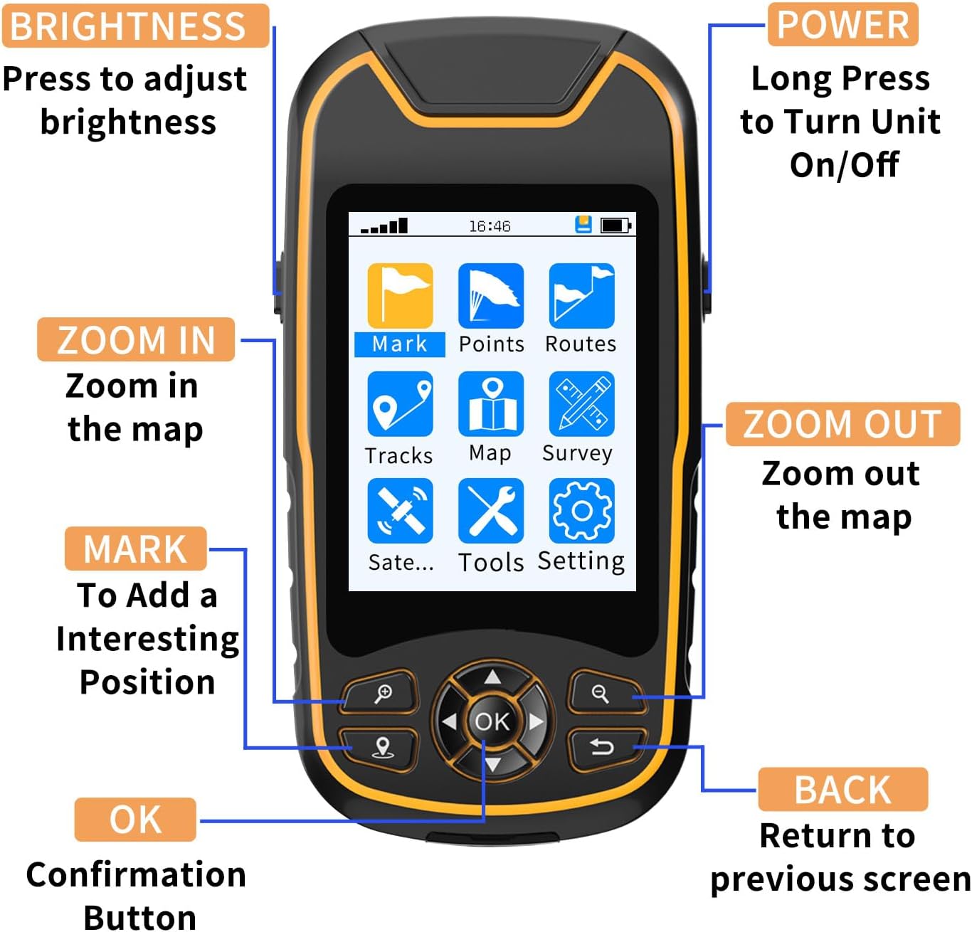
Image: A detailed diagram illustrating the functions of each button on the NiesahYan S180 Handheld GPS Navigator, including Power, Brightness, Zoom In/Out, Mark, OK, and Back.
- POWER: Long press to turn the unit On/Off.
- BRIGHTNESS: Press to adjust screen brightness.
- ZOOM IN: Magnifies the map view.
- ZOOM OUT: Reduces the map view.
- MARK: Used to add an interesting position or waypoint.
- OK: Confirmation button for selections and actions.
- BACK: Returns to the previous screen or menu.
4.2 Satellite Positioning (Multi-GNSS)
The S180 supports multiple satellite systems (GPS, GALILEO, BEIDOU, QZSS) to provide fast and accurate positioning. For optimal signal reception, operate the device in an open area with a clear view of the sky.

Image: The NiesahYan S180 GPS showing its satellite signal strength display, overlaid on an illustration of the global satellite network, emphasizing its multi-GNSS capabilities (GPS, Beidou, Galileo, QZSS).
4.3 Compass and Altimeter
The integrated 3-axis electronic compass provides accurate heading information even when stationary. The barometric altimeter offers precise elevation data, useful for tracking changes in altitude during your outdoor activities.

Image: The NiesahYan S180 GPS screen showing the compass navigation interface, displaying current coordinates, heading, and distance to target, with a clear compass rose.
4.4 Track Navigation and Waypoints
The device allows you to record your travel tracks and save specific waypoints. This feature is essential for retracing your steps or navigating to predefined locations.

Image: The NiesahYan S180 GPS displaying a map with a recorded track, current location, and navigation data, indicating its track recording capabilities.
4.5 Coordinate Naming and Input
You can save longitude and latitude coordinates, name them for easy identification, and manually input specific coordinates. The device supports WGS84 and UTM coordinate systems.
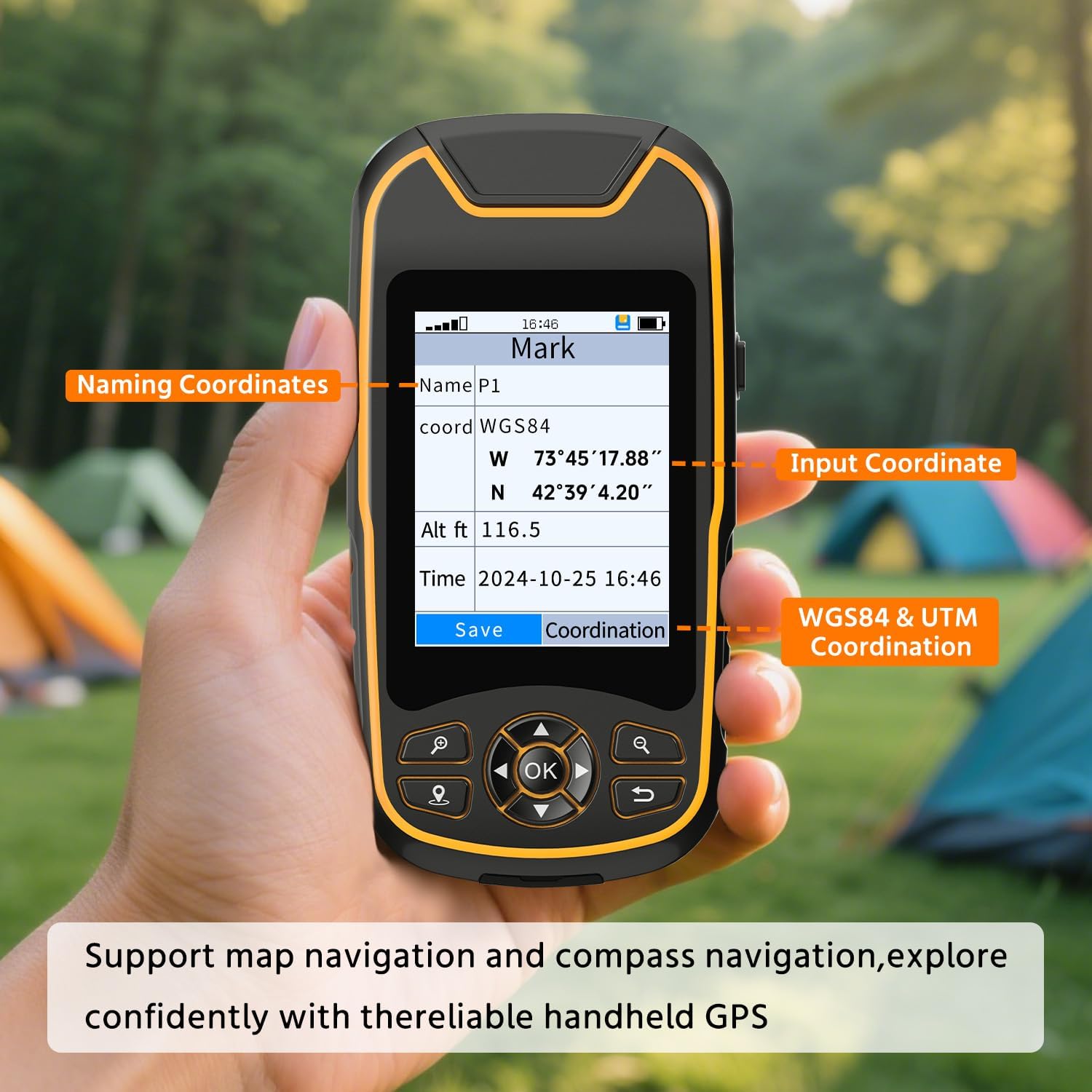
Image: A hand holding the NiesahYan S180 GPS, with the screen displaying options for naming coordinates and inputting WGS84 & UTM coordinates, demonstrating its data entry features.
4.6 Data Management and Export
The S180 has 32GB of internal memory, capable of saving up to 20,000 waypoints, 1,000 routes, and 1,000 tracks. You can connect the device to your computer via USB to export data, which can then be viewed and analyzed using software like Google Earth.

Image: The NiesahYan S180 GPS connected to a desktop computer, illustrating its 32GB storage and the ability to export data for viewing on platforms like Google Earth.
5. Maintenance
5.1 Water Resistance
The NiesahYan S180 is rated IP66 for water resistance, meaning it is protected against powerful water jets. While it can withstand rain and splashes, it is not designed for submersion. Ensure the USB-C port cover is securely closed to maintain water resistance.

Image: The NiesahYan S180 GPS device shown in a rainy outdoor setting, resting on wet leaves, demonstrating its IP66 water-resistant design.
5.2 Cleaning and Storage
Clean the device with a soft, damp cloth. Avoid using harsh chemicals or abrasive materials. Store the GPS in a cool, dry place away from direct sunlight and extreme temperatures when not in use.
6. Troubleshooting
6.1 No GPS Signal or Poor Accuracy
- Ensure you are in an open area with a clear view of the sky.
- Avoid dense tree cover, tall buildings, or deep canyons which can obstruct satellite signals.
- Allow several minutes for the device to acquire satellite signals upon power-on, especially after moving long distances.
- Verify that Multi-GNSS support is enabled in the settings.
6.2 Device Not Turning On
- Check the battery level. Connect the device to a charger and allow it to charge for at least 30 minutes before attempting to power on again.
- Ensure the power button is pressed and held for the required duration.
6.3 Map Display Issues
- Verify that the correct map region is loaded and selected for your current location.
- If maps are missing or corrupted, refer to Section 3.3 for instructions on downloading offline maps.
6.4 Screen Readability in Bright Sunlight
- Adjust the screen brightness using the dedicated BRIGHTNESS button.
- Angle the device to minimize glare.
6.5 Device Freezes or Becomes Unresponsive
- Press and hold the Power button for 10-15 seconds to force a restart.
- If the issue persists, contact customer support.
7. Specifications
| Feature | Specification |
|---|---|
| Brand | NiesahYan |
| Model Name | NiesahYan S180 |
| Screen Size | 3.2 inches |
| Special Feature | USA topo map, Waterproof |
| Connectivity Technology | USB |
| Map Type | Topographical |
| Included Components | Hanging Rope, Plug, USB Cable, User Manual |
| Battery Life | 36 hours |
| Mounting Type | Handheld |
| Operating System | Windows (for data transfer/map management) |
| Memory Storage Capacity | 32 GB |
| Touch Screen Type | Non-touchscreen |
| Display Type | LCD |
| Human-Interface Input | Buttons |
| Control Method | Push Button |
| Supported Satellite Navigation System | BeiDou, GPS, Galileo, QZSS |
8. Warranty and Support
NiesahYan offers a 24-month promise for this product, ensuring quality and reliability. For warranty claims, technical support, or any inquiries not covered in this manual, please contact NiesahYan customer service through the retailer where the product was purchased or visit the official NiesahYan website for support contact information.

Image: A gold badge prominently displaying '24 MONTH PROMISE', signifying the product's warranty period.